Floris Schiferli draws some ideas based on Mental Charlois

20 11 2011


Floris Schiferli is an artist and architect living in Oud Charlois. For one of his recent projects, he decided to use the material from Mental Charlois, give his own interpretation and make some very interesting proposals.

He organised the Charlois inhabitants in several population groups:


Charlois inhabitants timeline by Floris Schiferli

Historically the area was a farmer’s village on the other side of the Maas. With the development of the Rotterdam harbour though it soon transformed into a workers neighbourhood. International “imported” workers soon joined Dutch worker families. In the 1970’s with the independency of the former colonies Surinamese and Antilleans came to complete the colourful mix of inhabitants. The latest addition is the artists, who came here the last 5 – 10 years.

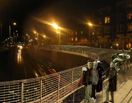
Young people hang out, close to the Maastunnel


Maastunnel hangout:

In the conclusion map of good and bad spots in Charlois, the artificial barrier between the river Maas and Oud Charlois, the Maastunnel is marked mostly as a good spot. Rather looking at cars then ships? The new youth is fan of the monumental Tunnel trace, or is it the great waste-burn Castel designed by Maarten Struis the real near-by attraction? Since teenagers are a hunted group in the south of Rotterdam, the area around the Maastunnel entrance is a good hangout, not too far from the supermarket, donner-kebap and their homes. The ventilation system of the Maas tunnel blows out warm air, so the spot is always slightly warmer than the outside temperature. The dike that contains a bike path can easily be misty and works as a visual barrier, so the users can have some privacy. Plus, the traffic noise is covering up the sounds of teenagers having fun. Seems like a win-win situation!

Bar and Restaurant terrace on Charloisse Kerksingel


Charloisse Kerksingel:

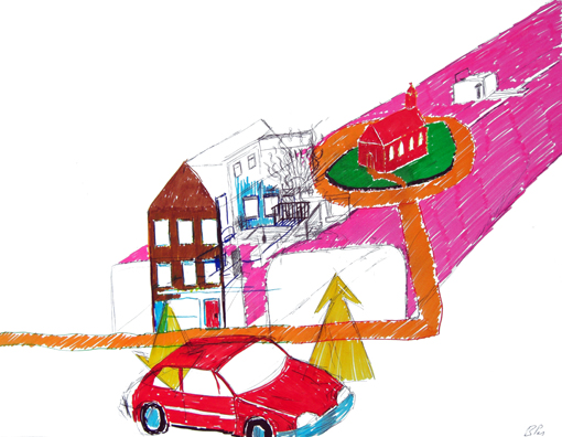
Several people have already proposed this idea. In the old times, the church used to be centre of public life, as everything happened around it. Nowadays, the amputated green park around the old Church, enclosed by a little fence, discourages the possibility to use it as a square. Looking at the movement traces, we understand the importance of the place, while a look at the historical maps show that different shops used to be located facing the church. There is simply no other square in old Charlois within so much potential. Houses all around function as a form of social control and there is already a cafe-bar and restaurant and a gallery. Imagine the sun shining, having a cold beer and some good finger food…

Proposed new metro station at Zuiderpark


Metro stop South-park.

A great park with hardly any visitors considering its size. Strangely enough the Zuidpark appears in most of the maps as a reference point but hardly anyone mentions that they actually go there. The movement traces form a big circle around it. A lot of people are depending on the public traffic, especially in the south of Rotterdam. Making the park more accessible could actually increase the number of visitors.



Mental Charlois at W_lf_rt Project Space

17 12 2010

Here are some images from our last public Mental Charlois workshop at W_lf_rt Project Space.

l

This slideshow requires JavaScript.


Mental Charlois at Laleli Mosque

25 08 2010

Here are some pictures from our workshop at the Laleli mosque. It was our first men-only workshop and it was very interesting, mostly because of the language barrier, which we had to overcome! At the end, it prooved to be a very interesting experience on finding ways to communicate and our friend, Dursun Koca, helped us a lot!

This slideshow requires JavaScript.


short workshop in Veldacademie

27 05 2010

In the framework of our exhibition of the results of the Mental Charlois workshop with the students of the Hugo de Grootschool we organised a short Mental Charlois workshop with participants the visitors of the exhibition.

We managed to concentrate a good amount of new maps from a random sample of people living in Oud Charlois. Attending an exhibition and participating at a mini-workshop was an interesting way to generate a discussion about out working method and the procedure of mental mapping in general.

This slideshow requires JavaScript.


exhibition in Veldacademie

20 05 2010

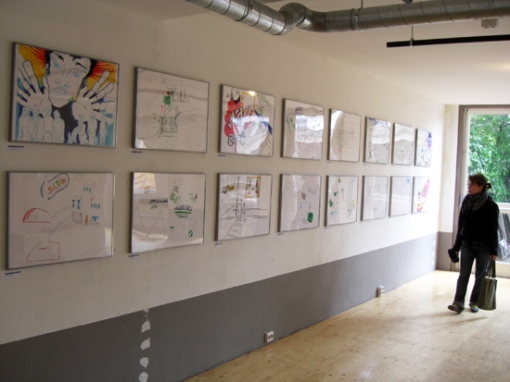
The results of the workshop with the students of the Hugo de  Grootschool were exhibited in Veldacademie, a research laboratory of  the faculty of Architecture of TU Delft in Oud Charlois. Participants of the workshop were happy to see their creations on the wall and a lot of people from the neighborhoud passed by to see the results.

This slideshow requires JavaScript.


Overlapping the routes of the Hugo de Grootschool students

12 05 2010
This is the map that came from overlapping the routes the students usually follow.We also asked them to indicate in green the places they like, where they feel safe and they prefer to go and in red the places that they don’t find beautiful or attractive. Most students find comfort in their house and like the park, eventhough not many go there often. Maashaven is concidered by many not a nice area. The school is probably the place which creates the most mixed feelings!
Overlapping of students' routes and indicating good and bad places
Overlapping of students’ routes and indicating good and bad places


what students said over Charlois

8 05 2010

 “Actually I like to stay in my bedroom.”

Nuey

 “Als het in de avond is, is het nergens heel veilig in Feijenoord. Maar omdat ik er al 16 jaar woon ben ik het wel gewend.”

Ismahan

  “Ik voel me overal veilig.”

Diresh

 “Zuiderpark is wel een leuke, rustige plek om een leuke tijd door te brengen. Maar Pendrecht is best onveilig door de hangjongeren.”

Alexandra 

 “I feel comfortable going to farms because I feel peace when I’m there. I also like going to the playground of the children. I like looking at them when they play.”

Jenna

  “Mijn buurt is niet heel fijn, je hebt daar veel drugscafés en het is gevaarlijk daar. De buurt van mijn vriendin is rustig en fijn.”

Austeja

  “Op Zuidplein ga ik vaak naar McDonald’s om te eten. Ik zwem ook vaak in Tropicana.”

Sara

 “My neighborhood is so cool but near the station Zalmplaats it’s not cool because people make so much noise from the morning till night. But if you walk much further then you feel the silence and see the beauty of Ruisvoornpad.”

Clara 

 “Op vrijdagen/zondagen bezoek ik (islamitische) lezingen. Ook ga ik wel eens naar de moskee.”

Latifa

  “De Oliphant, het is daar lekker rustig en daar komt bijna niemand. Het is lekker rustgevend.”

Asli


Mental Charlois at Hugo de Grootschool

27 04 2010

In March 2010 we were requisted by the Historisch Museum of Rotterdam [http://www.hmr.rotterdam.nl/] to collaborate with the Mental Charlois Project for their research project “The Town as Muse”.

Students of the Hugo de Grootschool, in Charlois, divided in two groups and lead by their teacher Lidwine Loorbach, participated to the Mental Charlois workshop, giving completely different and unexpected results compared to the last time.

This slideshow requires JavaScript.


Exhibition in W_lf_rt Project Space

11 04 2010

The results of the first workshop took place at W_lf_rt Project Space [http://wolfart.nl/] the 19th of July 2008.

People could see their drawings framed, hanging in the exhibition space. The overlapping of their routes and the new Charlois outline were also presented in that occassion.


workshop pictures

31 03 2010

Here you can see some pictures of our first Mental Charlois workshop in t’Ot’je the garden in the artist’s block in Struitenweg.

It was a beautiful summer day and everybody seemed to have a good time during the workshop. The atmosphere was great for the participants to come together, discuss and enjoy the workshop

This slideshow requires JavaScript.


Oud Charlois outline map

10 03 2010

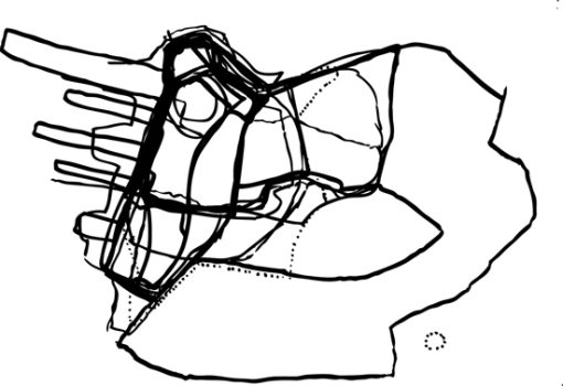
Participants were asked to outline what they think Oud Charlois is. Most of the results circled the area around the Oude Kerk. Some included the Waalhaven and some went as far as the Maashaven. The overlapping of all imaginary limits create a new map of Oud Charlois.

oud charlois outline produced by the overlapping of individual perceptions


overlapping the routes

28 02 2010

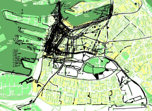
overlapping the individual routes of the participants of Mental Charlois

Even though this seemed to be the most technical step of the whole process, it revealed the differences in the way people move and direct themselves. The busiest areas of Charlois stick out and a strong relation to the center becomes prominent. Looking at the drawing as a pure pattern is very fascinating.

movement patterns produced by overlapping the individual routes of the Mental Charlois participants


the Mental Maps

15 02 2010

mental map by Annemarie Piscaer

Mental map by Annemarie Piscaer

charlois mental map by Boris Pas

Mental map by Boris Pas

Charlois mental map by Done Boyuk Tekin

Mental map by Done Boyuk Tekin

charlois map by Gerard Jurgens

Mental map by Gerard Jurgens

charlois mental map by Lisa Overmann

Mental map by Lisa Overmann

mental map by Rikke Korswager

Mental map by Rikke Korswagen

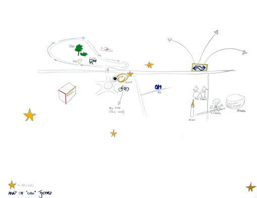
Mental map by Tjeerd van Waijenburg 

Mental map by Friederike Mainka

mental map by kamiel verschuren

Mental map by Kamiel Verschuren

Mental map by Martijn in ‘t Velt

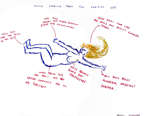
Mental map by Samuli Schielke

charlois mental map by Yu Kuramoto

Mental map by Yu Kuramoto

charlois mental map by cristina ampatzidou

Mental map by Cristina Ampatzidou


wat mensen gezegd over Charlois

15 02 2010

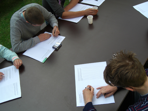
participants filling in the questionaire


people wrote about Charlois…

8 02 2010

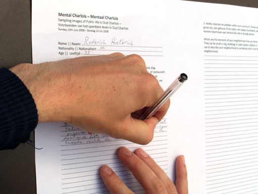
participant wirtting down his opinion on Charlois

and so many birds! Even those little parrots – like in Dusseldorf [my home].

Friederike Mainka

There are many artists in Charlois. This is not visible to the outside [for example neither B.a.d. nor Studio Pompstraat look like something interesting from the outside]. But this becomes visible by the people walking on the street. They reveal a sense of fashion and artistic quality in their clothing.

Annemarie Piscaer

The tunnel is the best entrance to Charlois, by bike or walking, and then you come out of the long staircase and there is the open view to the North skyline, because there is so much openess there. It is always very windy, on the rough side.

The Waalhaven, stroll around the harbour area. See the industrial businesses [there is a nice wood shop] a little strange car garage [I wouldn’t buy a car there] boat equipment [large chains etc] the metal scrap yard [there are always guys with a lot of scrap, waiting to sell them].

Thijs Ewalts

There are a lot of really ugly places combined with some beautiful ones. There’s almost nothing in between these two extremes, even though there is a lot of “in between space”.

It is remarkably clean in Charlois when it comes to graffiti. In suburbia, I ‘m sure there are more.

Rikke Korswagen

Charlois starts in Maastunnel. On my left there is the huge chimney of the garbage factory and on the right a grass field, where on Sundays middle aged men drink beer, half naked, after a football game.

important places:

the metal box with the ultra sound, located on the corner of Clemenstraat, just before MCD.

Katita Chrysanthopoulou

Netto market is very relevant to me because it is the first supermarket I discovered when I came here.

I feel this neighbourhood is like what luxurious resorts try to be, but they usually end up very pathetic and fake. There are many green spaces, people are well mannered and kids are outside, playing on the streets.

Mofa


workshop steps

8 02 2010


1.       the written text

People are invited to describe their everyday movements in a small piece of text.

The purpose of this step is to help people organize their thoughts over their life in Charlois. Writing is a familiar way for most people to organize their thoughts and it also provides to us extra help in re-reading the sketches of the mental maps.

2.       the mental map

Participants are requested to draw their mental map of Charlois. This includes places they have mentioned in the previous exercise, their house, their ordinary movements, places they visit regularly and places they consider to have an important character for the image of the neighborhood.

3.       the actual map

People are required to transfer the elements mentioned on their mental maps on the actual map of Charlois [or Rotterdam]. They have to locate their house and to trace the routes they are following in their everyday movements, the places they are visiting on a regular basis.

4.       Oud Charlois outline

The participants are asked to outline what they feel as the boundaries of Oud Charlois.


on mental mapping

31 01 2010

“The limit of a place is specified by what a body can do in that place, that is, by its sensory activity, its legwork, its history there…. The cosmos is sensed in concrete landscapes as lived, remembered, or painted: it is the immanent scene of finite place as felt by an equally finite body.”

Edward S. Casey, The Fate of Place: A Philosophical History

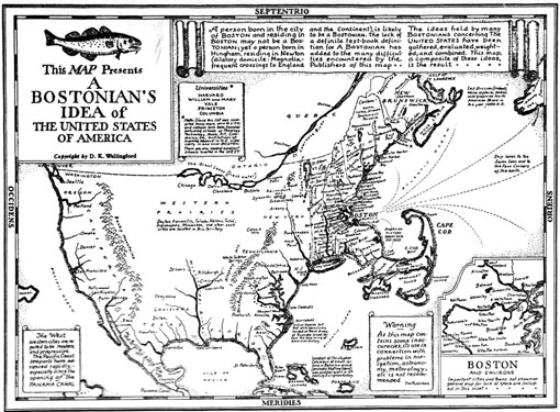
A person’s perception of the world is known as a mental map. A mental map is an individual’s own map of their known world. Mental maps of individuals can be investigated.

We have mental maps of our room in residence, our home, our neighbourhood, our town, the local supermarket, other places we have visited and even places we have never been to but about which we have acquired information from a variety of sources. These mental maps represent our knowledge of the spatial organization of our environment as well as information about the attributes which we associate with different locations or regions.

The way to draw a mental map is by interviewing people, by asking them to draw their map of a city or region or by asking them directions to a certain point.

We believe that mental maps are useful, not only as an analytical tool on how people perceive their environment but also as a quantitative  and qualitative tool to measure how people use their surrounding.

Peter Gould & Rodney White, Mental Maps 1974, A New Yorker’s Idea of the USA.


Peter Gould & Rodney White, Mental Maps 1974, A Bostonians Idea of the USA.


on perception of urban spaces

31 01 2010

“Perception is an act, not a response; it’s an achievement, not a reflex.”
J.J. Gibson

Perception is primal element of our existence as it allows us to negotiate with our environment and affects our everyday actions and behavior.

As Husserl supports, who was the first to point this out, there is certain intentionality in our perception. It is not a combination of random stimuli but it is a whole of senseful information. A person walking on a street, looking for a post office will ignore the garbage bins along his way, because this information is not useful to him at that moment but a person wanting to dispose his meal left over, will pass by the post office seeking for a garbage bin.

From these simple movements in the city, one forms his mental image of the city, thus the more interaction he has with the direct urban environment, the more detailed his mental image will be.

Of course our perception is affected, among others, by socio-cultural aspects that shape our goals, needs and intentions.

J.J. Gibson separates the “literal perception” from the “schematic perception”, using the first one to describe the properties of the world that we perceive directly and the second for the cases when the grasp of the “noematic nucleus” is active and more complex, thus it requires to extend ones mental abilities in space and time. The important difference between these two is that schematic perception is subjective and unpredictable, because it is dependent on the perceivers point of view [cultural and social structures, goals, needs, intentions].

Our perception is emplaced.

Every human activity, mental or physical, is place bound. We act, move, see, talk, think in a specific spatial surrounding. The fact that place cannot be moved, cannot be displaced, creates a perceptual difference between place and objects. A cup is a cup everywhere but Saint Peter is only one and even if it is duplicated it will not be St Peter because it is will be in another spatial context, the spatial condition of each place is unique. This is a reason why the study of the perception of urban spaces is so interesting.

The cover of the New Yorker, in March 1976, presenting a birds eye view of New York City and the cover of the New Yorker, in December 2001, presenting a plan of the metropolitan New York. The perceptual difference of the city from the other map is evident. Our idea of the city has changed from a localized human point of view to a global flat map.